


Implementing Agency: - NECTAR
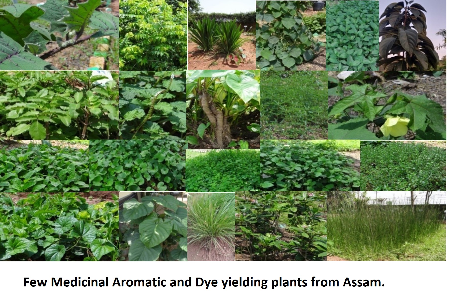
During the last few decades there has been a resurgence of interest on Medicinal, Aromatic and Dye yielding plants (MADyP) across the globe owing to their demands either for use in different healthcare systems or for manufacture of various health care products. Being one of the biodiversity rich regions of Indian subcontinent and one of the world’s biodiversity hot spots, North-Eastern India harbours a plethora of Medicinal, Aromatic and Dye yielding plants. Works on different aspects of Medicinal, Aromatic and Dye yielding plants of Northeast India focussing their conservation, cultivation, sustainable development, processing, market link-up, inventorization, bioprospecting, etc. and even application of biotechnology have been carried out in different institutions/ organizations for their promotion and development. However, no unified effort has been made so far to bring together all the relevant aspects of Medicinal, Aromatic and Dye yielding plants for incorporation in policy decisions for the development of MADyP sector in this region.
The North-Eastern states are rich in plant resources and the region is one of the prominent mega biodiversity hot spots of the world. More than 70% of the land mass of the eight states is predominantly hilly with climatic heterogenicity and diverse agro climatic zones. The region is abundantly blessed with plant genetic resources, out of these many have been identified as rare, endangered, and threatened. A few are on the verge of extinction.
A region cannot prosper ignoring its inherent resources. This call for immediate conservation measures and sustainable utilization. Keeping this objective and the viability of developing the MADyP sector in the region for deriving economic benefit to the rural communities and developing entrepreneurship in view, NECTAR has initiated several measures to encourage and envisaged an intervention in the state of Assam ideated on “Assessing Medicinal.
Outcome and People Benefited: -
- A total of 19 locations were identified where there are areas having MADyP cultivation.
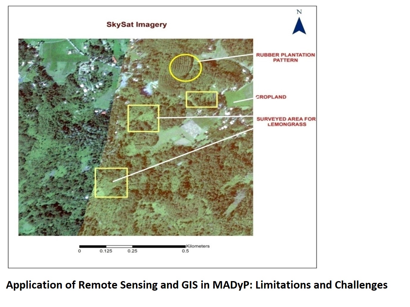
- Geotagging of the identified MADyP cultivation areas has been done for studying spectral signature in high resolution imagery.
- With the identified MADyP farmers/ entrepreneurs/ traders were interviewed and information and views were received from them regarding their farming, farm plots, challenges, prospects, requirement of support in terms of technology, a finance and market linkages as well as suggestions for improvement of the MADyP sector
- Based on the information obtained during the field work, future activities of the project such as inventory making, mapping, consultation with farmers and capacity building of farmers and entrepreneurs etc. will be planned and carried out
- Information obtained from farmers and geo-coordinates collected from their farm plots have been converted to GIS maps.
- A database has been created with information about various species of MADyPs observed, details of farm plots mapped and other important details of the farmers along with different issues and experienced by the farmers along with their views on improving the state of MADyP cultivation and entrepreneurship in Assam.
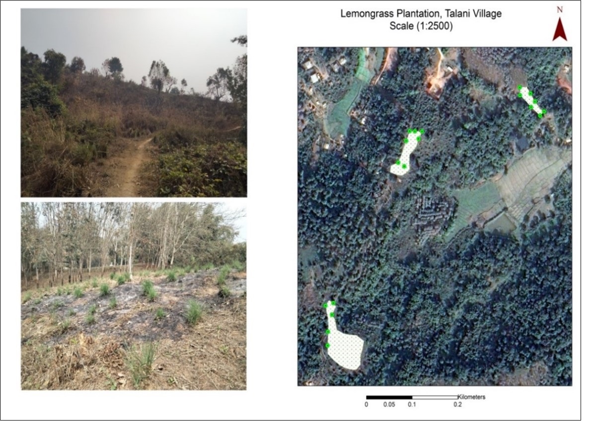
Pilot study at Khetri, Kamrup Metropolitan District, Assam:to devise a suitable remote sensing (image processing) technique for mapping MADyP species in both small and large areas.
Implementing Agency: - NECTAR
During the last few decades there has been a resurgence of interest on Medicinal, Aromatic and Dye yielding plants (MADyP) across the globe owing to their demands either for use in different healthcare systems or for manufacture of various health care products. Being one of the biodiversity rich regions of Indian subcontinent and one of the world’s biodiversity hot spots, North-Eastern India harbours a plethora of Medicinal, Aromatic and Dye yielding plants. Works on different aspects of Medicinal, Aromatic and Dye yielding plants of Northeast India focussing their conservation, cultivation, sustainable development, processing, market link-up, inventorization, bioprospecting, etc. and even application of biotechnology have been carried out in different institutions/ organizations for their promotion and development. However, no unified effort has been made so far to bring together all the relevant aspects of Medicinal, Aromatic and Dye yielding plants for incorporation in policy decisions for the development of MADyP sector in this region.
The North-Eastern states are rich in plant resources and the region is one of the prominent mega biodiversity hot spots of the world. More than 70% of the land mass of the eight states is predominantly hilly with climatic heterogenicity and diverse agro climatic zones. The region is abundantly blessed with plant genetic resources, out of these many have been identified as rare, endangered, and threatened. A few are on the verge of extinction.
A region cannot prosper ignoring its inherent resources. This call for immediate conservation measures and sustainable utilization. Keeping this objective and the viability of developing the MADyP sector in the region for deriving economic benefit to the rural communities and developing entrepreneurship in view, NECTAR has initiated several measures to encourage and envisaged an intervention in the state of Assam ideated on “Assessing Medicinal.
Outcome and People Benefited: -
- A total of 19 locations were identified where there are areas having MADyP cultivation.
- Geotagging of the identified MADyP cultivation areas has been done for studying spectral signature in high resolution imagery.
- With the identified MADyP farmers/ entrepreneurs/ traders were interviewed and information and views were received from them regarding their farming, farm plots, challenges, prospects, requirement of support in terms of technology, a finance and market linkages as well as suggestions for improvement of the MADyP sector
- Based on the information obtained during the field work, future activities of the project such as inventory making, mapping, consultation with farmers and capacity building of farmers and entrepreneurs etc. will be planned and carried out
- Information obtained from farmers and geo-coordinates collected from their farm plots have been converted to GIS maps.
- A database has been created with information about various species of MADyPs observed, details of farm plots mapped and other important details of the farmers along with different issues and experienced by the farmers along with their views on improving the state of MADyP cultivation and entrepreneurship in Assam.
Pilot study at Khetri, Kamrup Metropolitan District, Assam:to devise a suitable remote sensing (image processing) technique for mapping MADyP species in both small and large areas.
Implementing Agency: - NECTAR
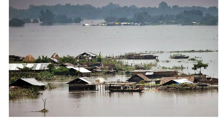
Assam is the land of red river and blue hills. The mighty river Brahmaputra is the lifeline of Assam flowing from east to west over a length of approximately 650 km. Tributaries from both northern Himalayan range as well as from the southern plateau meets at this mighty river making it more dynamic and aggressive. With the arrival of southwest monsoon, the streams get rejuvenated. Their flows become more intense, and the calm river system no more continues in its leisurely pace and starts taking ferocious form. The water flows above the banks, expands throughout the low-lying valley, wetlands and ponds get submerged. Croplands become large sheets of water, roads and railway lines get split due to heavy water current. This rising and overflowing of water especially onto normally dry land is commonly termed as ‘flood’. From centuries, people are living in river valley as they are fertile, provide easy access to drinking water and navigation facility. The Brahmaputra valley is inhabitant of 27 million people and its fertile soil boost large agrarian economy. Though the valley provides promising nourishment in livelihood and culture, yet it brings adverse impact in terms of periodic flood losing life, damaging land and property, bringing people under poverty. According to a report by Central Water Commission between 1953 to 2016, on average 26 lakh people are affected every year in Assam due to flood and erosion with a total annual damage around rupees 128 crore.
Prior to the advancement of science and technology, natural disasters are considered as divine punishment upon humanity. Scientific knowledge transforms age old belief about natural disaster with logical explanations. People cannot prevent floods or earthquake or cyclones to occur but can be well prepared adopting proper technological armor. Satellite technology provide new insight in understanding our planet’s surface activities. Remote Sensing and GIS technology is the most UpToDate intervention considering different aspects of natural disaster. Satellite imageries are giving clue where flood situation is most likely to occur, what are the factors responsible for the flood, how many villages are being affected, how to plan for rescue operation, how to minimize the damage etc. etc.
Keeping in view the recurrent flood and erosion scenarios of Assam, NECTAR is also giving emphasis on possible technological intervention to mitigate flood impacts. Three flood and erosion prone districts; Morigaon, Majuli and Dhubri, across the River Brahmaputra from upstream to downstream are selected for the pilot study. Morigaon, an agrarian district of central Assam is highly prone to flood which persists from April to October. Similarly, thousands of people get effected each year due to flood in Dhubri and Majuli district. Majuli, declared as a new district of Assam in 2016, obtain its unique physiography due to vast dynamics of Brahmaputra and its tributary channels making it highly erosion prone. Remote Sensing and GIS technology is adopted in understanding flood history, river course changes, real time inundation, socio-economic impacts etc. in these districts. UAV technology provides high resolution detailed mapping of flood structures.
Outcome and People Benefited: -
NECTAR aims in enhancing community resilience through awareness, education, skill development and capacity building; promotion of appropriate technology for raising flood resilient infrastructure and to provide science and technology input for sustainable flood and erosion management.
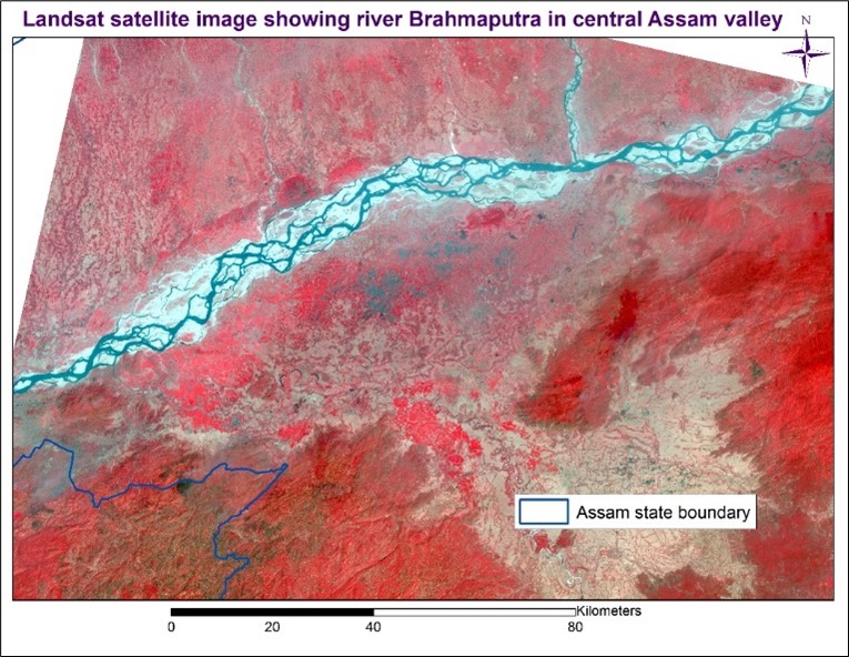
Fig. Satellite image showing river Brahmaputra at a particular date
Implementing Agency: - NECTAR
Assam is the land of red river and blue hills. The mighty river Brahmaputra is the lifeline of Assam flowing from east to west over a length of approximately 650 km. Tributaries from both northern Himalayan range as well as from the southern plateau meets at this mighty river making it more dynamic and aggressive. With the arrival of southwest monsoon, the streams get rejuvenated. Their flows become more intense, and the calm river system no more continues in its leisurely pace and starts taking ferocious form. The water flows above the banks, expands throughout the low-lying valley, wetlands and ponds get submerged. Croplands become large sheets of water, roads and railway lines get split due to heavy water current. This rising and overflowing of water especially onto normally dry land is commonly termed as ‘flood’. From centuries, people are living in river valley as they are fertile, provide easy access to drinking water and navigation facility. The Brahmaputra valley is inhabitant of 27 million people and its fertile soil boost large agrarian economy. Though the valley provides promising nourishment in livelihood and culture, yet it brings adverse impact in terms of periodic flood losing life, damaging land and property, bringing people under poverty. According to a report by Central Water Commission between 1953 to 2016, on average 26 lakh people are affected every year in Assam due to flood and erosion with a total annual damage around rupees 128 crore.
Prior to the advancement of science and technology, natural disasters are considered as divine punishment upon humanity. Scientific knowledge transforms age old belief about natural disaster with logical explanations. People cannot prevent floods or earthquake or cyclones to occur but can be well prepared adopting proper technological armor. Satellite technology provide new insight in understanding our planet’s surface activities. Remote Sensing and GIS technology is the most UpToDate intervention considering different aspects of natural disaster. Satellite imageries are giving clue where flood situation is most likely to occur, what are the factors responsible for the flood, how many villages are being affected, how to plan for rescue operation, how to minimize the damage etc. etc.
Keeping in view the recurrent flood and erosion scenarios of Assam, NECTAR is also giving emphasis on possible technological intervention to mitigate flood impacts. Three flood and erosion prone districts; Morigaon, Majuli and Dhubri, across the River Brahmaputra from upstream to downstream are selected for the pilot study. Morigaon, an agrarian district of central Assam is highly prone to flood which persists from April to October. Similarly, thousands of people get effected each year due to flood in Dhubri and Majuli district. Majuli, declared as a new district of Assam in 2016, obtain its unique physiography due to vast dynamics of Brahmaputra and its tributary channels making it highly erosion prone. Remote Sensing and GIS technology is adopted in understanding flood history, river course changes, real time inundation, socio-economic impacts etc. in these districts. UAV technology provides high resolution detailed mapping of flood structures.
Outcome and People Benefited: -
NECTAR aims in enhancing community resilience through awareness, education, skill development and capacity building; promotion of appropriate technology for raising flood resilient infrastructure and to provide science and technology input for sustainable flood and erosion management.
Fig. Satellite image showing river Brahmaputra at a particular date
आखरी अपडेट : 26-02-2025 - 15:33


